Viewfinder:Hold the phone sideways, point the camera at the mountain you’re interested in and it displays its name. Tap on the name to get all the details of the mountain and navigate towards it.
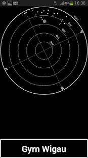
Toposcope: Hold the phone flat and all the hills are shown as a toposcope. The higher the mountain, the brighter the dot. Tap on a dot to see its name. Tap on the name to get all the details of the mountain and navigate towards it.
Nearby Hills:Shows all the nearby hills. Tap on the name to get all the details of the mountain and navigate towards it.
Search. Search for a specific hill, anywhere in the UK or Ireland.
Plan. Now you can use any location in the UK without actually being there. Allows you to plan in advance of a trip which hills to climb and which maps you'll need.
Uses the British Hills database (version 13.2), contains all Munros, Corbetts, Grahams, Nuttalls, Marilyns, Wainwrights, Birketts, Humps, Arderins, Vandeleur-Lymans, Sims, Furths and County tops.
Ideal for hill walking in The Lake District, the Highlands of Scotland, Ireland, Wales, Dartmoor, the Pennines, the Yorkshire Dales or anywhere that has hills.
We do not host Mountain Navigator Free on our servers. We did not scan it for viruses, adware, spyware or other type of malware. This app is hosted by Galad and passed their terms and conditions to be listed there. We recommend caution when installing it.
The APK Download link for Mountain Navigator Free is provided to you by apps112.com without any warranties, representations or guarantees of any kind, so access it at your own risk.
If you have questions regarding this particular app contact the publisher directly. For questions about the functionalities of apps112.com contact us.

|
| ||||
| Downloads: 13 | ||||
| Updated At: 2024-04-19 20:29:41 | ||||
| Publisher: Treknology | ||||
| Operating System: Android | ||||
| License Type: Free |